Wednesday, December 14, 2016

Importance Of Wilderness

'We must speak loudly for this silent place' -Amy Freeman

If my body had a low battery light it would have been blinking…we had just finished the unofficial first half of the WNBA season, condensed due to an extended Olympic break right in the middle of the season.  My wedding was 12 days away, but I had a few free days to recharge before everyone descended upon the Twin Cities.
After talking things over with Ali, we decided we were in a good spot regarding the wedding details and I could bounce to the Gunflint Trail.
Our family has had a cabin on Hungry Jack Lake, just off the Gunflint Trail in Northern Minnesota for many decades.  Originally purchased by my Great Grandpa, I have made it up there every year of my life but one (shoulder surgery knocked me out in 2000)
There are two cabins, a big cabin and a little cabin, and we are just a short paddle across Bearskin Lake to the BWCA the ‘Crown jewel of Minnesota’ as Governor Dayton called it recently.
There’s running water and electricity, but no cell phone access, TV or internet, the perfect place to unplug and charge up.
I loaded my kayak on the roof of the car and hit the road at 6am on Wednesday morning, light rain was falling as I pulled on to 35 and headed north, sipping coffee from my Gunflint Trail mug that I use daily.
The rain hung around until north of Temperance River before tapering off as I pulled in to Grand Marais.
Stopping at the store I loaded up on food, spend a little time hanging by the water listening to a guy play guitar but I was itching to get up the trail and out on the lakes in my yak.
Turning on the dirt road off the trail there is always butterflies of excitement in my stomach even to this day, the anticipation of getting to spend time up here puts a lopsided, goofy grin on my face every time.  This was my first trip back since a winter stop over the year prior, and I couldn’t wait to get there.
After unloading the car, I took the kayak down to the lake and immediately hopped in, the clouds were low and gray, no wind moved as I glided across the glassy surface of the lake.  The silence wraps itself around you up here.  I paddled to the far end of the lake into a bay and just drifted, leaning back I closed my eyes and felt totally at peace, just a small speck floating in a big lake, mind drifting but not thinking of anything, finally letting go. 


Later that night as I sat on the dock eating dinner the sun peeked out for a moment and in that instant I heard the sound of kids, flying from the neighboring cabins down to their docks and SPLASH, in they went.
It reminded me of all the years we came up as kids, my brothers and I spending all day on the dock.  Swimming, eating lunch, fishing, swimming in the afternoon, sailing, canoeing.  Dock days we called them, lunch was summer sausage with cheese, crackers and apples on paper plates held down by rocks so they didn’t blow away.  Nights were spent playing cards against Mom and Grandma, losing money to Grandma and her refusing to play the next hand until you paid up…having to take that walk from the big cabin to the little to get your wallet and make good.
For a few years, all the kids we grew up with playing at the Cabin had grown up and you didn’t hear those sounds as much, but now there was a new crop of kids.  I heard shouts of kids playing king of raft, laughing, splashing, saw them canoeing in the little bay in front of their dock.  It put a smile on my face to see these kids playing in nature, not playing Poke Mon Go, or staring at a screen.
The next day I put the kayak in early with a plan to head into the BWCA, for the past few years I had been supporting efforts to Save the BWCA from mining operations that could pollute the watershed that flowed right into this Wilderness Area.
It scared me to think of this place being contaminated, not being able to float in the middle of the lake and drink the water, not being able to peer deep down on a sunny day and see the big fish that populate these lakes, not being able to take my kids to these areas and jump in for a swim after a hot day of paddling.
The sun was shining this morning as I hopped in the kayak, even though it was early I could already hear the kids down the lake splashing and paddling around.  I paddled down to the first portage, one I have done a million times.  Shouldering the kayak, I crossed the trail into Bearskin Lake.  From there I had to cross the lake to the Daniels Portage, there was little more chop on Bearskin as there always seems to be. 


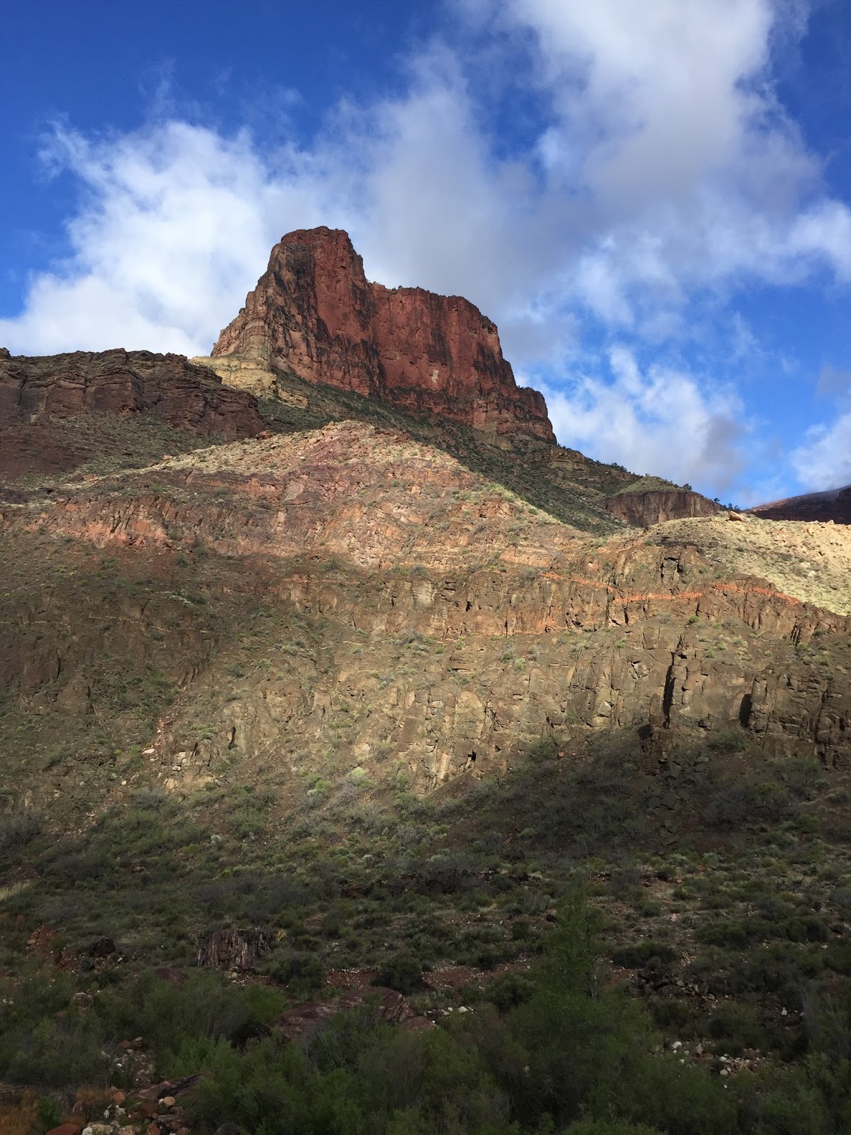
Looking to my left you could see the rocky top of Caribou Trail, to my right several canoes headed out from Menogyn, and others crossing the lake towards the Duncan portage.
As I slid into Daniels Lake I paddled along the bluffs on the left side, remembering as kids coming here and fishing off those big rocks, the water so clear you could see down to the even bigger rocks below and the shadows of fishing swimming around.  I remembered lunching on those rocks, the way the sun warmed your skin as we reclined on the rocks, each of us finding our own little ‘easy chair’ to relax in.
I paddled further into the lake, debating on making the link up from here to Rose Lake but not feeling the effort of that seriously long portage.
The sun was high, not a cloud in the sky, just a deep blue with a light wind, I paused at the far end of the lake, drifting, watching the shoreline reflect on the surface of the lake.  Our wedding was a little over a week away, the hay was in the barn as my brother liked to say, I was excited to welcome everyone in town and more excited to pledge my love and my life to Ali.  She loved coming to this place too, and the thought of one day bringing our family to follow some of the same trails that I trod as a kid was a great vision.
Heading back to the portage I ran into a guy and his brother, about my age with their two kids climbing into their canoe.  The guy mentioned it was the kids first trip the BWCA, he had been coming up for years but finally they were old enough to handle the canoeing and camping and they were headed out for a few days.  It was so great to see, another generation of kids heading into the Wilderness, learning to love it as their parents did, that’s what this area needs, defenders of all ages, people who understand the importance of preserving it for the next generation and the one after that and so on. 


I portaged over to Duncan Lake, remembering the time my Dad, brother and I were on this lake, the wind was driving hard, the waves crashing against the side of our big old Grumman canoe, Paul was in the front, Dad in the back, me on the bottom of the boat in the middle hanging on to the sides as waves splashed over, praying we would make it to shore safe.  Little different today in my kayak with very little wind.  
Knifing through the water I headed towards the Rose Lake portage, looking at the shore recalling all the hiking trips we’ve taken over the years along the Border Route trail that connects through here.  It’s amazing how certain trees remind you of things, there was a spot where for some reason Alex started singing Sugar Ray and how every time I see that spot that song pops in my head, the part where my body was wrecked with cramps while running back here and I had to gut it out to the road with my brother and cousin, skiing through here during a winter trip to the frozen falls.  So many memories.


I left my boat at the portage, walking down the stairway portage to Rose, laughing at the thought of last summer here with my uncle, cousins and brothers and the laughs we shared over lunch by the lake.  


Crossing the stream, I headed to my favorite spot, but this time it looked totally different, a few weeks’ prior a huge storm had ripped through the area uprooting trees and changing the landscape.
Making my way to the bluff I saw my usual spot was gone but in its place, was a new ‘easy chair’ I reclined on the rock, sheltered from the sun by the root base of a tree that had been uprooted by the storm.  I settled back, wrapping myself in the silence, gazing off towards Canada and Arrow Lake, feeling a light breeze blow through occasionally, and eventually drifted off to sleep.  The kind of naps you dream about at work sometimes. 
I woke slowly as the sound of people drifting over the roots to my sheltered little spot.  A family was taking in the views too, we chatted for a while before I headed out, paddling across Duncan to the Moss Lake portage.
Dropping into Moss the sun was arching towards the west, I thought of the times I have camped on this lake, the epic sunsets, eagles soaring overhead, the time spent just sitting on the big log at the portage shooting the bull with whoever I was with.  The laughter, one of the best parts of canoe trips, the silly little things that make you crack up.  How easy it is to open up to your paddling partners, the conversations that span the absurd to the serious. 
I paddled into the lake letting my thoughts drift over to my vows, how do you tell the woman of your dreams how much she means to you?  How do you put into words how much you love and care about her?  Is it possible to take all those feelings and compress them into a few sentences?  The thing about Ali that I knew right from the start, was how right it felt.  How comfortable I was, how I could be myself without judgement, how all I wanted to do was make her laugh, spend time with her.
As I floated thinking about all those things, I thought about this land too.  How do you put in to words how special this area is?  How can someone who has never put a paddle in the water and floated through a crystal-clear lake understand why we shouldn’t allow a mining operation on the edge of this Wilderness?
It can be hard to put into words what this place means to people, it’s a silent place that can’t speak for itself, you need to show people what it means that’s why I thought the Freeman’s year in the Wilderness was so important.  To shine a light on this area, bring it to the public mind, make people understand we don’t have many spaces like this left and how important it is to keep it wild.
I relaxed on the dock that evening, listening to the sounds of the loons as the sky faded to black and the stars began to come out.  The sound of the kids playing in the lake slowly quieted as it began to get dark and the silence was total.  It was a quick trip, but amazing what it did to recharge my battery and fill my soul.  I closed my eyes, imaging for a moment sitting here in the future with my wife and family, soaking in the beauty of this place and hoping that it would stay as it is for that to happen. 


Details on how you can help can be found here 
https://www.savetheboundarywaters.org/

Saturday, November 26, 2016

#SaveTheConfluence


May you walk gently through the world, and know it’s beauty, all the days of your life-

“It would start right there,” Matt said pointing to an outcropping near the rim of the Grand Canyon “Then it would angle down to that point there, and eventually to the floor of the Canyon.” 

We were standing on the Beamer trail a few hundred feet above the Colorado River, squinting into the sun reflecting off the glowing Canyon walls, on our way to the Confluence of the Colorado and the Little Colorado, hoping to catch it on one those days where the minerals in the Little gave it that blue/green coloring.
This was my second attempt to reach the Confluence, an adventure Matt had put in my head two years prior, but one that he had been planning for since 2010, having two previous attempts thwarted. 


Matt was a Canyon addict, he knew everything there was to know about this giant hole in the ground.  He knew all the trails on both the South and North sides, the history of those trails, the stories of the people those trails were named after & could name all the landmark buttes, bluffs and explain the difference between the type of rock in the Red Wall to the Tonoto level.  He was the perfect guide, historian, and adventure buddy. 


Together we had made four other hikes into the Canyon, and spent the time between those journey’s plotting and scheming the next one.
Until 2014 I had never been to the Grand Canyon, but when I was in Patagonia, Chile for an Ultra Marathon in September of 2013 I got to chat with a lot of folks from other countries and the conversation usually turned to them asking me if I had been there.  I said no, and they were shocked, they had all traveled from Australia, Chile, Argentina, Brazil, Japan and beyond and been there, why had I not? I lived there and didn’t check out the beauty in my own backyard? 


After returning from that trip I began to really dig in to the Canyon, I planted to seeds of a Rim To Rim To Rim attempt (running from the south rim to the north rim and back via the corridor trails) with two of my buddies Greg and Mitch and then reached out to Matt who lived in PHX and who I knew spent a lot of time in the Canyon. 


Matt and I had worked together in Minneapolis for a short time, and while we had a lot in common had never really had an opportunity to get to know each other before he and his wife moved to PHX for a new job.
I shot him an email, did he have any advice about the Canyon, thoughts on the R2R2R…what came back was a detailed, mile by mile breakdown not only of the trails we would cover but what he brought on his attempts with his brother.  That kicked off a correspondence that has not stopped since. 


We tried to rendezvous that Spring during our R2R2R attempt but despite all the information Matt provided, this was a lot bigger of a journey than we thought.  Our attempt started & finished in the dark that day while Matt drove up from PHX and went rim to river and out, making it back home before we climbed out.
That summer I was in PHX for work and we connected, talking of the Canyon and began to plan a backpacking trip that fall, I was hooked, couldn’t get the Canyon out of my mind. 


In the fall of 2014, my technically 3rd trip into the Canyon (after our R2R2R Ali had flown in and met us, she and I did a tour of Sedona, Zion & then did the Canyon rim to river over the course of a week) Matt, his brother Ben & I were planning a long weekend loop down the Tanner trail on the East end of the Canyon along the Escalante and back out. 


When we reached the river that day, Matt & I posted up under some trees right on the shore playing Uno and cooling off in the river while waiting out the worst of the heat.  It was there Matt told me about the Confluence, this magical place where the water flows blue/green and you can see the complete contrast with the green of the main Colorado.  It sounded amazing, we had driven along the Little on our way into the Park from the East end and you could see where it cut through the ground before joining up with the Colorado.
After returning to MN from that trip, we began to shoot emails back and forth again, adventures we wanted to try, environmental issues that were threatening some of our favorite spots (development along the south rim of the Grand Canyon being a big one at the time) we signed petitions to make our voices heard and then Matt brought up the Confluence. 


Since that last trip, I had researched it and seen the pictures, read what it meant to the Navajo people and the mining ruins along the trail.
Matt secured a permit and that fall we gave it a shot.  I arrived in PHX on a Sunday morning, originally, we had planned to head straight to the Canyon but it was getting blasted by rain so we spent the day at Matt’s house with his wife and two sons, heading out around 4am the following day. 


That backed our itinerary up meaning things were going to have to go perfect for us to complete this ’37-mile knee-buckling’ (according to backpacker magazine) journey.
The first day was great, sun was shining, the journey down Tanner was smooth (smooth as could be expected) we had to do some route-finding along the bluffs above the river and through the tamarisk we eventually made it to our campsite, tired, hot and dusty but no worse for wear.
From there, things didn’t go as planned, the river was running brown, full of sediment making filtering an issue, not to mention problems with our stove and dark clouds in the distance we never made it beyond Palisade Rapid. 


It was raining when we woke up and while we waited for it to taper off we realized we were not gonna make it out to the Confluence.  The trail is a few hundred, if not thousand feet above the river, offering no chance at water (and with our filtering issues we wouldn’t have been able to get drinkable water anyway) the rain just wouldn’t stop plus our weather report showed worse storms still to come.
So, we packed up and headed back out, one day busting tail all the way down only to turn and head back out the next, reaching the car just as the storm arrived. 


We would be back, we just didn’t know when…. during the winter, Matt sent me a link about more development threatening the Grand Canyon & the Confluence specifically.  There was a group who wanted to build a tram from the top of the Canyon down to the bottom, ending right at the Confluence.  This threat had been made before but suddenly it had legs under it and was moving swiftly.
We signed petitions, made our voices heard in online forums opposing the development, urged our friends and family to do the same.  


As winter turned to Spring, my brother, buddies Mitch & Cano meet Matt at the Canyon for another R2R2R adventure and he again spoke of the threats to this amazing area. 


A few weeks after returning I got an email from him, it was a forward from the National Park Service approving his permit request back to the Confluence…there was no note from Matt just the permit.
I sat at my desk, looking at the dates wondering if I could pull it off.  I responded ‘Is there room on that bus for me?’  Come hell or high water (or no water in the case of the desert) we were gonna make it to the Confluence. 


Over the next few months we traded emails plotting the trip, and talking about how important it was to get there before it became developed.  I remember one text from Matt that really stood out ‘I can’t wait to be standing at the Confluence watching that blue-green water flow, but more so I can’t wait to be standing there with my boys someday telling them about the first time I made it out there and how it looks the exact same”
Just as the journey to the Confluence shouldn’t be as simple as stepping into an air conditioned tram, getting there for me wouldn’t be easy either.  Originally, I had planned to fly out Thursday night, we would head to the Canyon camp on the rim, then hike to the river & Palisade Rapid the following day, get to the Confluence the next, head back to Tanner to camp & then climb out. 


Instead the WNBA Finals went to game 5 and I had to change my flight to Friday morning, we left the airport around 11am arriving at the Canyon in the afternoon with a few hours of daylight remaining. 
Packed up quick and hit the trail, slowly making our way down the now familiar Tanner Trail.
We made it through the Red Wall before the sunset and hit the long, slow, grinding Tonto layer as darkness fell.  Headlamps out, we just continued to grind, hitting the river around 6pm in total darkness.
From there we navigated the bluffs at the start of the Beamer trail, and eventually settled on a campsite around 745 in the sandy area just beyond them. 


The next morning, we rose around 6am, a solid breakfast of eggs and hash browns to fuel up for a long day, 2.5 miles to our next campsite where we would drop our packs, then another 6+ out to the Confluence and back.
The weather was perfect, chilly in the shade as we headed toward Palisades, right at river level, the mighty Colorado flowing fast and smooth to our left, red rock to our right.  This time there was a lot less route finding, with no rain for the past few weeks the trail was a lot easier to spot than last year.
We found our site (dubbed ‘The Secret Garden’ after the Springsteen song) dropped our big packs and pulled out day packs loaded with water and snacks. 


We headed out knowing there would be a big climb at the start then just following a relatively level trail in and out of the slot canyons down to the Confluence.
The initial climb didn’t mess around, we scrambled through the loose rocks, leaning heavily into our trekking poles, stopping to catch our breath, partly from the climb and partly to soak in the beauty of the sun rising, hitting the canyon walls across the river making them glow.
We were fortunate to be on the east side of the river so we were in the shade for most of our hike out but we knew coming back we would be heading directly into the sun. 


We fell into a rhythm on the trail, making good time through the flat sections, getting slowed as we navigated the ups and downs of each slot canyon (there are something like 20 of them, some dropping a couple hundred feet only to climb back up that on the other side to regain the trail.) 


After a few hours, the left side of the river was totally in the sun and we were starting to get some on our side, Matt walking ahead of me slowed to a stop.  We knew we were getting close, we could see where the canyon split off to the right of Chuar Butte.  


“Look, you can see it coming in!” He said.  I looked at the river, there was a sand bar in the middle of the river, the Colorado was flowing green but along that sand bar there was a little streak of the blue-green color that the Little Colorado flowed.  We were close and with so little rain recently both rivers were free of the usual sediment that causes them to flow brown. 


We rounded a bend and were stopped in our tracks, the contrast of colors, the rivers together but separate like oil and water for a few hundred yards before the main Colorado swallowed up the Little. 


Hiking down to the shore we pulled our shoes off, sinking our feet in to the freezing cold water, wading up to our knees through the clay-like sand, laughing like children that we had finally made it to this sacred spot.
The sky was such a rich, deep blue color, the side walls of the canyon a rich gold, the Little Colorado aqua-blue, the main Colorado green, so much depth and definition to the landscape.  We sat on rocks, in silence, soaking it all in. 


Eventually we found some shade and settled in, listening to the flow of the water, leaning back against rocks that made up nature’s easy chair, relaxing after the effort of the past two days to get here.  Life slowed to the essentials, water, food, shelter.  Matt talked of the mining ruins along this trail, I drifted off momentarily letting the whirlwind of the past few months go, feeling light, connected to the landscape, simple.
After a few hours, we packed up wanting to get back to our camp while there was still some daylight so we could filter water and cook up a big meal. 


The journey back was challenging as we went into the sun, taking caution to duck out of it and rest from time to time, eventually making it to our campsite with plenty of daylight left.  We filtered water at the rapid, cooked dinner down there and settled onto some rocks watching the sun set on an amazing adventure. 


The Confluence is a sacred spot to the Navajo, and having been there I can see why.  Not knowing that it was minerals that caused the color of the water to change, one would believe there was something mystical about it.  Sitting at its shore and watching it flow, even now knowing about the mineral deposits, it still feels mystical.  The Canyon ecosystem is held together so finely that any sort of disruption to it would have far reaching effects.  It reminds me of that Simpsons episode where Mr. Burns is told he has every disease ever discovered but they are all balancing each other out which is why he hasn’t died.  But, the doctor warned, ‘one common cold could kill you’.  To which Mr. Burns replied ‘So you’re saying I’m invincible…’ 


That is how I feel the Canyon is, and how people think of it.  It’s an environmental marvel, but it’s very fragile and we’ve already seen the impact that the dams have had on it and other developments.  You need to work with the Canyon, in unison, not think ‘It’s invincible’ because it’s not.  


A development like the Escalade project would not just impact and possibly soil the Confluence, but it would have an even greater impact long term throughout the entire Canyon. 
I would encourage everyone to oppose this project and other developments within the Grand Canyon, sometimes it’s okay for things to be hard to get to, sometimes things are better left alone, left wild, we need to think of the long-term impact not a short-sighted benefit.


Friday, May 6, 2016

R2R2R #2


"Do not imagine the journey is short; and one must have the heart of a lion to follow this unsual road, for it is very long...one plods along in a state of amazement, sometimes smiling, sometimes weeping."
-Peter Matthiessen 'Snow Leopard'

We were a few miles into the 1st Annual (even though that doesn’t make sense, we are hoping it become annual) Turkey Trudge when I broached the subject.
You’ve heard of Turkey Trots, a local 5-10K race before everyone pounds food for the rest of the day.  Well this year Mitch texted me on Monday night while I was working and said ‘You want to run 26 on Thursday morning?’  I thought about it…last time Mitch & I ran together was at the Wild Duluth in October, wasn’t sure I had a marathon in me in 3 days but thought ‘what the hell, been a while since I’ve seen Mitch might be fun.’ So I agreed and the Turkey Trudge began to take shape.

 
We would meet at my house in Mpls, and I would be in charge of 13 miles in my city arriving at the Minneapolis-St. Paul border where Mitch would take over with 13 miles eventually ending at his house where his wife & kids would give us a ride back.  (In the end it turned into 27 miles with some fun snow & trail running, hopefully we do get it again next year.) 


Anyway, early in the Turkey Trudge I floated the idea to Mitch…’Would you be interested in doing the Grand Canyon Rim to Rim to Rim run again this spring?’  When I was in the Canyon in the fall, my buddy Matt and I kicked the idea around, he had tried to run it once but didn’t quite make it, but had hiked it numerous times.  This year he was thinking maybe he would have enough time to train.
Mitch, Greg & I had run it back in 2014 and while we finished & had a great time, physically it took a toll on us.  So as Mitch & I talked about it that early, snowy November morning we talked of lessons learned from the first go round and what we might change this time. 


By December the plan began to take shape, Matt was in, Mitch was in, my brother Alex was in, and a buddy from Ohio U, Cano wanted to join from Florida.  Emails began to fly as the route was plotted, maps were studied and training kicked into high gear. 


That’s how we found ourselves standing in the PHX airport, Alex, Mitch & myself having arrived early Thursday morning (somehow Mitch & were dressed exactly alike) waiting on Cano to arrive with the rental car.  Once there we piled in and drove North to meet Matt. 


We loaded up on supplies at a local Walmart before hitting the road for a roughly 3 hour ride to the Canyon.
Along the way the conversation rolled from races we’ve run, books we’ve read, and what kind of things we would need for this adventure.  The weather was a real wild card, the canyon was getting hit with rain/snow and cold temps, but the forecast changes seemingly by the hour making it hard for us to plan ahead.
After driving through rain, snow & sleet we finally arrived at the Canyon only to find it socked in by a wall of clouds and fog.  Like nothing I had ever seen before.  You couldn’t see anything, there was a massive gaping hole right in front of us but as we stood at Shoshoni Point all we saw was a dull grey, like standing too close to a wall in an old building. 


We waited and slowly the canyon showed itself, a Grand Peep Show if you will.  Clouds parted to show glimpses of the red, white and green buttes and mesas that make up one of the most amazing places on earth.
Eventually we got a full look deep into the canyon & all the way across to the North Rim before snow began to fall & we headed back to the car.  A quick lunch and peek in to the abyss at Bright Angel lodge and we were back at the hotel beginning to sort out what we would carry the next day. 


Over the course of the months leading up to this trip Alex and Matt decided that they would hike for the day instead of run.  Both are very strong hikers and wanted to experience the Canyon that way.  They would start shortly after we did and take the same route down and out but in between explore some different areas.
So it was Mitch, Cano & I worrying over do we bring a rain coat and a long sleeve or just one, how many Cliff bars, sandwiches can we fit, how much water to start.  After a half hour or so our packs were loaded, heavy with food, water and trekking poles.  (The trekking poles were a new addition this trip, something we didn’t have in 2014 and they would make a world of difference.) 


Grabbed a quick dinner and crashed out with alarms set for 315 in the morning.
We rose, ate and hit the road arriving at the trailhead by 430.  A quick goodbye to Matt & Alex and we dropped in to the inky abyss. 


Moving slowly over the dark trails, working to get our footing we treaded lightly down South Kaibab trail.  Skipping over the logs in the trail, donkey leftovers and puddles from the previous day’s rain/snow we eventually made it to Skeleton point where we got our first glimpse of the inner canyon.
The sun was slowly rising to our right and behind us a trail of head lamps followed, groups of runners who took the first shuttle bus starting their run. 


The first 7 miles are quad crushingly downhill, not only that but you’re constantly skipping over rocks, logs and other obstacles that make it even more challenging.  Mitch & I had the benefit of nothing having run it before but spending a lot of time running trails in MN, while Cano didn’t have the experience coming from Florida.  You could see he was trying to find his rhythm on the trail, thinking about where to place his feet so as not to turn an ankle or go down. 


The sun was up when we hit the Tip-Off and got a great view of the green water of the Colorado flowing through the Canyon.  We worked out way down the final sections of switchbacks arriving at the river in under 2 hours which was what I had hoped. 


Made our way to Phantom Ranch and filled up with water and grabbed a snack knowing it was a tough 7 miles to our next stop Cottonwood.
We left Phantom and headed into the Box, a narrow section following Bright Angel creek, in 2014 this was the section that coming back was the hardest mentally.  The walls of the canyon soar seemingly straight up but tease you with views of the south rim.  You think you’re almost there but every time you turn a corner there is another wall.  On the way out in ’14 we also didn’t realize that you climb nearly 1,500 feet over this section and went out hard before realizing how hard it was. 


This time around Mitch and I found our normal rhythm, running and talking like a couple of old hens at a bridge game.  We talked of work, music we were listening to, and counted the bridges so we knew how many we’d cross on the way back. 


During this stretch Cano dropped back, searching for his own rhythm but struggling with the altitude.  Even though were at the bottom of the Canyon we were still around 2,500 feet above sea level and for someone who lives at or below sea level even this was a challenge. 


Together the three of us walked for a while as we cleared the Box into the open section of inner canyon.  The sun was high now, a few clouds hanging over the South and North rims but clear where we were.  Mitch & I surged ahead for a while rolling into Cottonwood in under 2 hours, feeling strong and like we were working but not pushing.  We met a group of 4 women who were running it there, they were just ahead of us and we would leap frog each other throughout the day. 


As we filled water, and grabbed some food Cano rolled in and said he was done.  He felt fine, but was struggling running so he was planning on just hiking for the rest of the day.  We went over a plan on where to meet after and made sure he was okay physically before we headed off to our next stop, The Pumphouse.
Cottonwood to Pumphouse is a quick jaunt, we arrived in around a half hour, signed the chalk board and pulled out our trekking poles for the climb to the North Rim.   


We leaned into the climb, aided by our poles and set a nice pace up to Roaring Springs and then plowed through the layer cake that makes up this ascent. 


Starting with the green layer, combining running and power hiking (walking with a purpose we called it) we moved into the red layer which is some of the most beautiful rock I’ve ever seen.  We switch backed up through there, crossing the bridge and headed to Supai Tunnel.  Just beyond the tunnel we came across a small older man who was pushing through the climb without the aid of poles, but with a pack and a mountain bike strapped to his back.
We recalled that there was a mountain bike race called the Arizona Trail Ride which started a few weeks ago and followed a trail from the Mexican border all the way to Utah and that part of it went through the Canyon.  But you weren’t allowed to bike on the Canyon trails so people had to carry their bikes on their back.  This guy said he’s slept for a few hours in the rain/snow last night and had just been humping this huge pack the rest of the time.  He was beyond inspiring and humbled us, every time you started to think you were tough, there was always someone stronger.  It was amazing to see him just slowly making his way up. 


We left him and continued our climb, low clouds hung over the final layer of this cake, the white layer.  It felt like we were getting closer but the clouds always felt just beyond our reach.  Switchback after switchback, were we getting closer to the top or was it moving away from us? 


Finally, we caught the clouds and moved into the ponderosa pine which signified the top of the North Rim.
As we stepped out of the trees at the North Rim we came across another biker who had just finished carrying their bike through the Canyon.  After I committed a social faux pau (I was so impressed when I arrived at the rim by the biker I bellowed ‘You sir are amazing’ only to have them turn around and reveal it was a woman, I quickly countered with ‘You mam are amazing’…next time a simple ‘hello would probably do.) 


We chatted with her for a bit as we filled our water, turned out she was from Ohio and had gone to Ohio University, same college as me, and was now 15 days into her ride with 60 miles left.  It was truly amazing. 
This was planned as one of our longer stops, prior to the North Rim our stops had averaged around 8 minutes, 10 tops. We made to the North Rim in under 7 hours which we were very excited about.  Fill up, get some food down, check gear/shoes etc. and keep moving.  Here though we sat down, ate a sandwich (or choked it down in Mitch’s case) sent a text via Sat Phone to Matt & Alex, updated them on Cano’s deviation and plan and rested in total for about a half hour. 


In 2014 on the way back down from the North Rim I flew, tossed myself at the hill like a snowboarder dropping in a halfpipe.  It was one of the most amazing things I have done, totally dialed in flying down the switchbacks, but in the process I wrecked my feet and toes and it made the rest of the run a challenge.
This time Mitch & I worked together, I followed him at a much more deliberate pace taking care of not only my feet and toes but also my quads.  The sun was coming through the clouds now and we knew we’d have a hot run back through the inner Canyon and the box.  Our conversation never lagged, chatting with people on their way up who dogged us for trailing the group of women who were a few hundred yards in front of us.
We rolled back to the Pumphouse, made a quick stop to stow long sleeve shirts and then I took the lead, back to Cottonwood where we would fill up for our final long run section.  Packs were heavy with water as we set out from Cottonwood, sun beating down we set a solid, steady pace though the heat. 


The plan on the way back was to take what we thought was a short cut to Ribbon Falls, check out the falls (and bypass a big ridge that would require a hearty uphill.)  We made it over to the falls, enjoyed the view then began to search for the rest of our short cut.  What we didn’t realize was there was no bridge back across the creek.
Rather than backtrack to the bridge we found a cairn pointing to the short cut but had to ford the creek in the process.  We took off our socks and shoes and stepped into the icy cold water.  It took your breath away but felt great on our battered feet.  The rocks at the bottom acting as little massagers as we waded to the other side. 


Once there we dried our feet, put on fresh socks and continued on towards the Box.
We hit the Box feeling strong despite the heat.  We had plenty of water and mentally knew what was ahead of us.  I took the lead and set a fast pace through this section which now helped us by being slightly downhill.  Our conversation slowed and eventually stopped as both of us locked in knowing that this section could make our break our run.  To this point we had been very smart, not pushing, monitoring calories, hydration, pace but now we knew get through this section and while there was still a formidable climb ahead the worst was over. 


Bridge one, done, then bridge two, bridge three shortly after that.  We slowed and walked for a bit as the sun sapped our energy, then bridge four and finally bridge five.  Another half mile or so and we made it Phantom Ranch.  We stopped and rested in the shade, both feeling the effort of that section.  Drinking as much water as we could and just relaxing for a few minutes.  Still roughly 10 miles to go but in our minds the worst was behind us. 


We filled up at Phantom knowing on the way out only Indian Garden (about the midway point) had water.  We walked and ate down to the river, crossed the bridge and began the rolling river trail.  After a few minutes trying to get our legs to work running in sand we just pulled out the trekking poles and did a combo power hike/run until we turned on to Bright Angel trail. 


In 2014 by the time we hit this section on the way out we had to use our headlamps and never really got to see what it looked like.
This time the sun was till high in the cloudless sky and we drank in the views.  I had crushed a lot of food and Phantom and was feeling it in my stomach as we leaned into the climb.  Between the heat, and my body trying to digest the hundreds of calories I slowed, focused on my breathing and waited for my body to absorb it all. 


As we had all day, Mitch took the lead.  Knowing I was struggling a little bit he led and kept up a steady stream of conversation until it passed and I was back to normal.  All day we switched off, if one needed a few minutes to get through something instinctively the other took over.  As we climbed the first rise I was back and we continued our banter throughout the climb. 


After a few miles of desert type climbing trees began to appear around a creek that ran down the South Rim, we knew we were getting close to Indian Garden.  Eventually it appeared like an oasis, trees, stream, buildings, benches, campground.  This was the last water stop over the final 5 miles out.  We didn’t want to carry a ton of water weight to the top so had to be smart.  Filled up bottles and decided to just keep draining our reservoirs in our packs. 


Texted Matt & Alex who had met up with Cano on the South Rim so everyone was together which was great.  They were just waiting on us. 


Off we went, the trekking poles ticking like a metronome, setting the pace and we followed.  Switchback after switchback, amazingly even this late into the adventure we felt good, strong.  Our splits from Indian Garden to 3-Mile rest-house to 1.5-Mile rest-house were eerily similar despite the fact that it felt like we were slowing down. 


The altitude forced us to work harder on the climb out but our pace stayed the same.  As always happens when you are getting close to the end our conversation turned to food.  Should we eat first then shower & hot tub, or vice versa.  After a few minutes of debate, I finally just gave in and told Mitch all I wanted to do was lay down on my back for like 5 minutes when we got out of here.  I said ‘I don’t care what we do after that I just want my 5 minutes’ we laughed remembering how I asked for the same thing back in 2014.
We were getting close, you could feel it, the sun had not quite set and we didn’t need headlamps as we turned into the final switchback.  Then I heard someone yelling, I turned back to Mitch and said ‘That sounds like Matt.’  He responded ‘It is’ we looked up and there was Matt & Alex leaning over looking down on us from the top of the rim.  Everyone laughed and they headed down to meet us at the final tunnel.  We climbed out together, 15 hours and 10 minutes to cover the roughly 48-50 miles of trail, a 4-hour improvement over 2014.


Everyone had a blast, Alex & Matt spend the day exploring and even spotted a couple big horn sheep.  Cano had spent the day in the Canyon climbing out a few hours ahead of us, and everyone was on a high.
We grabbed some food headed back to the hotel where I finally got a chance for my 5 minute lay down, making the most of it while smashing jalapeno poppers…


In 2014 the day after our R2R2R adventure the three of us were walking like extras in Michael Jackson’s Thriller video.  Barely able to move, quads, calves, feet shot. 
This time around we were moving better, not normal but a huge improvement over last time.  We lingered over the breakfast buffet telling more stories from the previous day’s adventure while rain/sleet/snow fell outside. 


Cano had to head back to PHX that morning to fly back to FL, the rest of us decided we felt good enough to take a hike and headed down Grandview Trail to Horseshoe Mesa, a 6 mile round trip hike to an old miner’s cabin and more spectacular views as the fog slowly lifted. 


We ended the trip with an epic Uno battle in the hotel room, punch drunk with laughter before crashing and heading home the next day.